Hawai’i Island — Regulated Fishing Areas
Kealakekua Bay Marine Life Conservation District
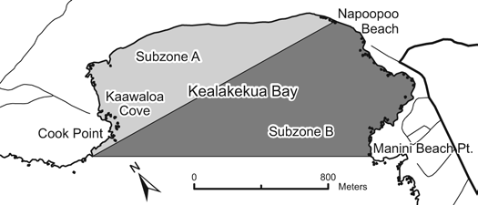
Location: Offshore of the Kealakekua Bay Historical State Park on the western coast of Hawai’i Island, from the high-water mark seaward to a line from Cook Point to Manini Beach Point. A line from Cook Point to the north end of Nāpō’opo’o Beach divides the District into Subzone A (north) and Subzone B (south). The Division of Boating and Ocean Recreation has also established provisions relating to boating, anchoring, and mooring within the MLCD.
Permitted
- Within Subzone B only: fish for, take, or possess any finfish with hook-and-line and thrownet; any legal fishing device or method except traps may be used for taking akule, ‘opelu, and crustaceans.
- Possess in the water any knife, shark billy, bang stick, powerhead, or carbon dioxide injector.
- With a permit, engage in activities otherwise prohibited for scientific, propagation, or other purposes.
Prohibited
- Fish for, take, or injure marine life (including eggs), except as indicated in “Permitted” above.
- Take or alter any sand, coral, or other geological feature or specimen.
- Engage or attempt to engage in fish feeding.
Old Kona Airport Marine Life Conservation District
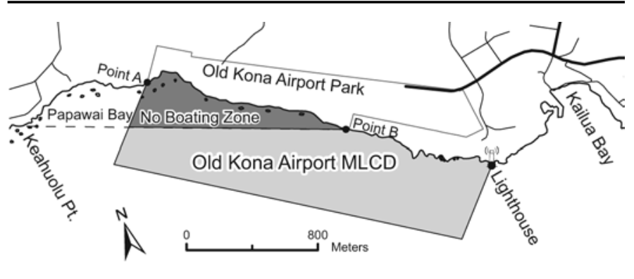
Location: (1) Waters offshore of the Old Kona Airport to the Kailua Lighthouse, bounded by a straight line from Point “A” seaward 500 yards, to a straight line from the Kailua Lighthouse seaward 500 yards; and (2) a “No Boating Zone” within the MLCD bounded by a straight line from Keahuolū Point to the southwestern corner of private property at Point “B”.
Permitted
- Fish for, take, possess, or remove akule by handline at night, and ‘ōpelu by lift or ‘ōpelu net method using bait or chum for commercial or home consumption.
- Fish for, take, possess, or remove any finfish for home consumption by throw net or pole-and-line (without reel) with bait from shore.
- Collect wana, wana halula, and hā’uke’uke with hand tool (no SCUBA gear) from June 1 to October 1.
- Use the state mooring not longer than three hours per boat each day on a first-come, first-served basis for non-commercial use.
- Commercial dive/tour operations may be conducted at the mooring and from shore with a permit.
Prohibited
- Fish for, take, injure, kill, possess, or remove any marine life, including live sea shell, ‘opihi, live coral, algae, or limu, or their eggs, except as permitted above.
- Take or alter any sand, shell, coral, rock, or other geological feature or specimen; or possess in the water any device used for taking or altering marine life or geological features.
- Feed or introduce any food material, substance, or device as an attractant, directly to or in the vicinity of any aquatic organism (except for the purpose of catching and removing that organism as permitted).
- Anchor a watercraft in the MLCD, or operate a motorboat or other motor-powered watercraft within the “No Boating Zone” except for emergency or enforcement purposes.
- Conduct commercial dive/tour activities except as indicated in permitted activities above.
Waialea Bay Marine Life Conservation District
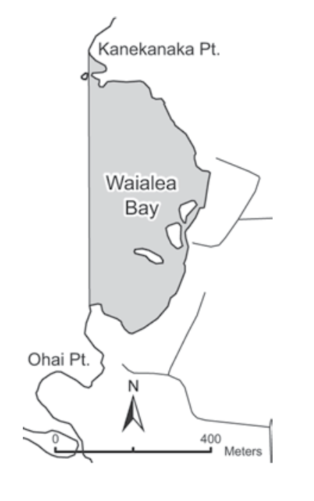
Location: Offshore of Waialea Bay along the northwestern coast of Hawai’i Island, from the high-water mark seaward to a line from Kānekanaka Point to the point immediately north of ‘Ōhai Point.
Permitted
- Have or possess any fishing pole and hook-and-line, and fish for, take, or possess any finfish using such gear.
- Possess in the water any knife, shark billy, bang stick, powerhead, or carbon dioxide injector.
- With a permit: possess and use legal nets to fish for, take, or possess finfishes over the sandy bottom areas within the District; also engage in activities otherwise prohibited for scientific, propagation, or other purposes.
Prohibited
- Fish for, take, or injure any marine life (including eggs), or possess in the water any device used for taking marine life, except as indicated above.
- Take or alter any sand, coral, or other geological feature or specimen; or possess in the water any device used for taking or altering geological features.
- Engage or attempt to engage in fish feeding.
Lapakahi Marine Life Conservation District
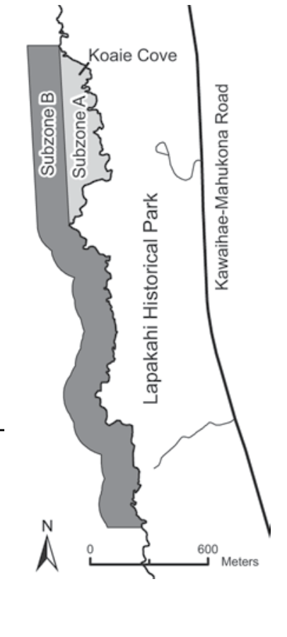
Location: Encompasses Subzone A (Koai’e Cove) and Subzone B, the adjacent shoreline area extending approximately 500 feet offshore of the Lapakahi State Historical Park on the northwestern coast of Hawai’i Island.
Permitted
- Within Subzone B only: fish for, take, or possess any ‘ōpelu by lift or ‘ōpelu net; any finfish or crustacean by hook-and-line or thrownet.
- Possess in the water any knife, shark billy, bang stick, powerhead, or carbon dioxide injector.
- With a permit, engage in activities otherwise prohibited for scientific, propagation, or other purposes.
Prohibited
- Fish for, take, or injure any marine life (including eggs), or possess in the water any device used for taking marine life.
- Take or alter any sand, coral, or other geological feature or specimen; or possess in the water any device used for taking or altering geological features.
- Engage or attempt to engage in fish feeding.
Waiākea Public Fishing Area
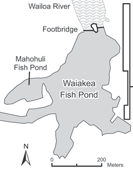
Location: That portion of the Waiākea fish pond in the Wailoa River State Park in Hilo, south of the footbridge over Wailoa River, including the flood control channel and Mahohuli fish pond. A boat launching ramp is located within the park. Rules of the State Parks System also apply.
Permitted
- Fish with not more than one line and one lure, or two single hooks in tandem no more than two inches apart.
- Use a dip net not exceeding 18 inches in diameter to land crabs lured to baited lines or to catch shrimp for bait purposes.
- Fish for, take, or possess an overall total of 20 fishes that include āholehole, ulua (including pāpio), and mullet, provided mullet shall not comprise more than ten fishes.
- With a valid Freshwater Game Fishing License, fish for, take, or possess any introduced freshwater game fishes.
Prohibited
- Operate boats for purposes other than fishing; use boats constructed of material other than wood unless provided with flotation; for any juvenile under 13 to operate any boat unless accompanied by an adult 18 or older; propel any boat with a fossil fuel motor; operate any boat between 7:30 pm and 6:30 am; or operate a boat at any time without a life preserver for each occupant.
- Permanently moor any boat.
- Swim, water ski, or engage in any other activity requiring immersion.
- Snag any fish.
- Enter into or fish in any area posted as fishing reserves or prohibited fishing zones.
- Fish for mullet during the closed season.
- Take or possess more than 3 Samoan crabs per day, or any Samoan crab less than 6 inches in width.
- Possess or use a spear.
Hilo Bay, Wailoa River, and Wailuku River
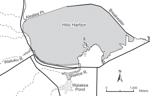
Location:
- Hilo Harbor — That portion of the bay in Hilo bounded seaward by the breakwater, and a line from the tip of the breakwater southwestward to Āle’ale’a Point.
- Wailoa River — That part of Wailoa River bounded by a line drawn across the mouth of the river and the footbridge at the mouth of Waiākea Pond, including Waiolama Canal upstream to the highest wash of the tidal water.
- Wailuku River — That part of Wailuku River between the Māmalahoa Highway bridge and Wainaku Avenue bridge.
Permitted
- Use of thrownets, ‘opae nets not exceeding three feet in any dimension, and nehu nets not longer than fifty feet to take nehu for family consumption or bait purposes.
- Taking of crabs with baited lines (a dip net may be used to land crabs lured to bait); or with not more than five crab nets not exceeding two feet in longest straight-line dimension and stretched mesh not less than two inches, provided nets are attended at all times.
- Commercial Marine licensees with a Bait License may take baitfishes.
- Licensed pond owners or operators may take young mullet (pua) or other small fish for stocking their fishpond (except in Wailoa River).
Prohibited
- Take or possess any aquatic life in violation of a season, minimum size, or other law, except pua as noted above.
- Use nets, except as indicated in permitted activities above.
- Take or possess more than 20 fish of mullet, moi, and all species of ulua (including pāpio and ‘omilu); bag limit shall not include more than 15 moi or 10 mullet per day.
- Fish with more than two poles with one line each, or two handlines, or with more than two hooks or lures per line.
- Use traps.
- Spear any crab; take or possess any crab with external eggs, with missing or mutilated abdomen or tail, or with a puncture wound.
- Take or possess more than three Samoan crabs per day.
- Snag any fish.
- Use or possess a thrownet or spear in Wailoa River.
West Hawai’i Regional Fishery Management Area
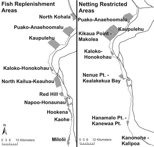
Location: Extends along the west coast of Hawai’i Island from Ka Lae, Ka’ū (South Point) to ‘Ūpolu Point, North Kohala, and from the high-water mark on shore seaward to the limit of the State’s management authority. Includes Fish Replenishment Areas (FRAs), Netting Restricted Areas (NRAs), Marine Reserve, and all Marine Life Conservation Districts and FMAs along the West Hawai’i shoreline.
Permitted
- All types of fishing, except as prohibited below.
Prohibited in Ka’ūpūlehu Marine Reserve
- Take any aquatic life, except the following may be taken seaward of the 20-fathom depth contour by hook-and-line: ‘ōpakapaka, kalekale, lehi, gindai, onaga, ehu, hāpu’upu’u, uku, ta’ape, roi, toau, nabeta, aku, ahi, tombo, a’u, ono, and mahimahi; also Kona crab by Kona crab net.
- Possess any marine life except as indicated above.
- Possess or use any fishing gear other than hook-and-line and/or Kona crab net.
- Deploy any fishing gear shoreward of the 20-fathom depth contour.
Prohibited in Selected Areas
- Fish feeding within any Fish Replenishment Area (FRA), Netting Restricted Area (NRA), Marine Reserve, or any other West Hawai’i Regional managed area.
- While within any FRA, MLCD, or FMA (other than Kiholo Bay FMA):
- Collect aquatic life for aquarium purposes.
- Possess aquarium collecting gear, or take or possess any aquatic life for aquarium purposes, except aboard a vessel in active transit (no collecting gear in the water during transit; boats adrift, anchored, or moored are not considered in transit).
Lay Net Fishing Restrictions (FRAs and NRAs)
Lay net fishing within the following FRAs and NRAs is prohibited: Puakō-‘Anaeho’omalu FRA, Kikaua Point-Mākole’a NRA (Kekaha Kai State Park), Nenue Point (Red Hill FRA)-Kealakekua Bay NRA, Hanamalo Point-Kānewa’a Point NRA, Kanonohe-Kalīpoa NRA, Kaloko-Honokōhau FRA.
Exception: Lay net fishing is allowed in Kaloko-Honokōhau FRA using a locally constructed, handmade lay net of natural fibers, in accordance with other lay net restrictions.
Prohibited Within the West Hawai’i Regional FMA
- Take or possess any pāku’iku’i.
- Take, kill, possess, sell, or offer for sale any specimen of: Hawaiian stingray, broad stingray, pelagic stingray, spotted eagle ray, blacktip reef shark, gray reef shark, whitetip reef shark, tiger shark, whale shark, horned helmet, and Triton’s trumpet.
- Possess more than five yellow tang larger than 4.5 inches total length, or more than five yellow tang smaller than 2 inches total length.
- Engage in SCUBA spearfishing, possess both SCUBA gear and a spear at the same time, or possess SCUBA gear and any specimen of speared aquatic life at the same time.
- Possess aquarium collecting gear, or take or possess any specimen of aquatic life for aquarium purposes between sunset and sunrise; without a valid aquarium permit; or while on a vessel that does not conform to registration requirements.
- Possess or use any net or container underwater to capture or hold aquatic life alive for aquarium purposes, which is not labeled with the commercial marine license number(s) of the person(s) owning, possessing, or using the equipment.
Lay Net Fishing (West Hawai’i FMA — General)
Prohibited:
- Use of a lay net not marked by buoys as specified and legibly displaying the permit number of the person using the net.
- Use of a lay net within 1,200 feet of another lay net (except two joined nets).
- Use of a lay net in water more than 80 feet deep.
- Use of a lay net for more than four hours during one set; or to set another lay net within 24 hours.
- Leaving a lay net unattended (considered unattended if net or surface buoys are not within eyesight of the person using the net).
- Retrieval in a manner that causes coral breakage from its attachment or into smaller pieces.
- Failure to inspect entire net within two hours after beginning set.
- To discard or leave any lay net or portion thereof in the water longer than four hours.
- Falsely identifying a lay net.
Lay net possession/use restrictions:
- No lay net without first obtaining a lay net permit.
- More than one lay net per person.
- Lay nets exceeding 125 feet in length or seven feet in stretched height; with stretched mesh less than 2-3/4 inches (three inches in Kailua Bay FMA); two or more nets joined for combined total length exceeding 250 feet.
- Multi-panel lay nets.
- A lay net without at least four identification tags as specified by DLNR (attached at each end of float and lead lines; permit number must be legibly displayed).
Persons using a vessel or float may use a total maximum of 250 feet of lay net, provided that at least two people are present and associated with the same vessel or float.
Aquarium Collecting Permits and Vessel Registration
- A West Hawai’i aquarium permit is required to engage in aquarium collecting activities.
- Holders of an aquarium permit may only take certain species; there are daily bag limits for achilles tang and certain sized kole. A copy of the “white list” and other restrictions may be obtained at the Kona DAR office or by downloading the administrative rule.
All aquarium-fishing vessels shall:
- Be registered yearly with DLNR to take marine life for that purpose.
- Permanently display the letters “AQ” on both sides as specified by rule.
- Fly a stiffened flag or pennant with the letter “A” as specified.
- Display a dive flag when divers are in the water.
- In the event an aquarium collecting vessel becomes inoperable, the operator shall immediately notify DOCARE or the United States Coast Guard by VHF radio and/or cellular phone.
Puakō Bay and Puakō Reef Fisheries Management Area
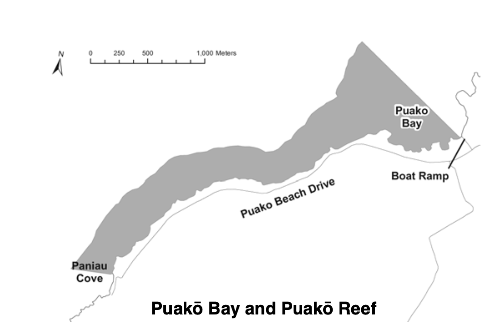
Location: That portion of the reef from the shoreline at the westernmost edge of the boat ramp, along a line drawn parallel with the ramp seaward to the edge of the fringing reef north of Puakō Point, then southwesterly following the fringing reef a minimum seaward distance of 250 yards (or to the edge of the fringing reef if one occurs beyond 250 yards), to a line due west of the small cove at the southern end of Puakō Beach Road.
Permitted
- Possess aboard any boat or watercraft any legal fishing gear and any fish or other aquatic life taken outside of the area.
- With a permit, engage in activities otherwise prohibited for scientific, propagation, or other purposes.
Prohibited
- Possess or use any type of net except thrownet.
- Engage or attempt to engage in fish feeding.
Kona Coast Fisheries Management Area
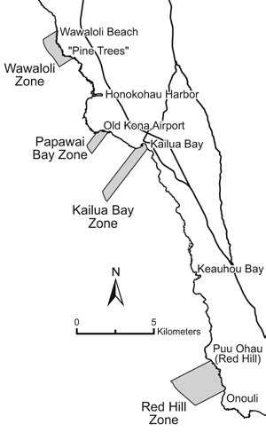
Location: Four FMA Zones on the southwestern portion of Hawai’i Island, each bounded by two lines extending seaward at right angles from shore and marked by signs on shore. The seaward boundary is at a depth of 100 fathoms (600 ft):
- (a) “Wawāloli Zone” — From south of Wawāloli Beach to south of Wāwahiwa’a Point
- (b) “Papawai Bay Zone” — From Keahuolu Point to the northwestern end of the runway of the Old Kona Airport
- (c) “Kailua Bay Zone” — From Kukailimoku Point near the Kailua lighthouse to the former swimming pool at the Kona Inn Shopping Village
- (d) “Red Hill Zone” — From Pu’u Ōhau (“Red Hill”) to Onouli
Permitted
- Catch fish in the Zones with legal fishing gear for personal consumption.
Prohibited
- Collect any aquarium fish within the Zones.
- Engage in fish feeding within the Zones, except for ‘ōpelu fishing.
Kiholo Bay Fisheries Management Area
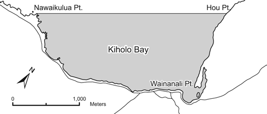
Location: That part of Kiholo Bay enclosed by a straight line drawn from Nāwaikūlua Point to Hou Point, including the lagoon known as Wainānāli’i Pond, but not Luahinewai Pond.
Permitted
- Aquarium fish permittees may use small-meshed nets other than thrownets, provided the person is within visual range of the net at all times.
Prohibited
- Possess gill nets within the Fisheries Management Area.
- Engage or attempt to engage in fish feeding.
Kawaihae Harbor
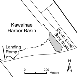
Location: Kawaihae, South Kohala, on the northwest coast of Hawai’i Island. Restrictions apply to the south small boat basin.
Permitted
- Take any legal-size fish in season with not more than two lines, or two poles or rods and lines.
- Use hand nets not exceeding three feet in any dimension to take shrimp or nehu for bait purposes, or to land fish already hooked.
- Within Zone B only: use nets of mesh size not less than 3 inches to take fish, or akule net to take akule only, provided nets shall not be in the water between sunset and sunrise, or remain in the water except during active retrieval or unloading of fish.
- Within Zone B only: use spears or thrownets.
- Commercial Marine licensees with a Bait License may take baitfishes.
- Licensed pond owners or operators may take young mullet (pua) or other small fish for stocking their fishpond.
Prohibited
- Snag or attempt to snag any fish.
- Herd, chase, or pa’ipa’i fish out of Zone A by swimming, diving, or from a boat, resulting in fish being taken by net.
- Otherwise fish for or take aquatic life, except as indicated in permitted activities above.
- Engage or attempt to engage in fish feeding.
Kailua Bay Fisheries Management Area
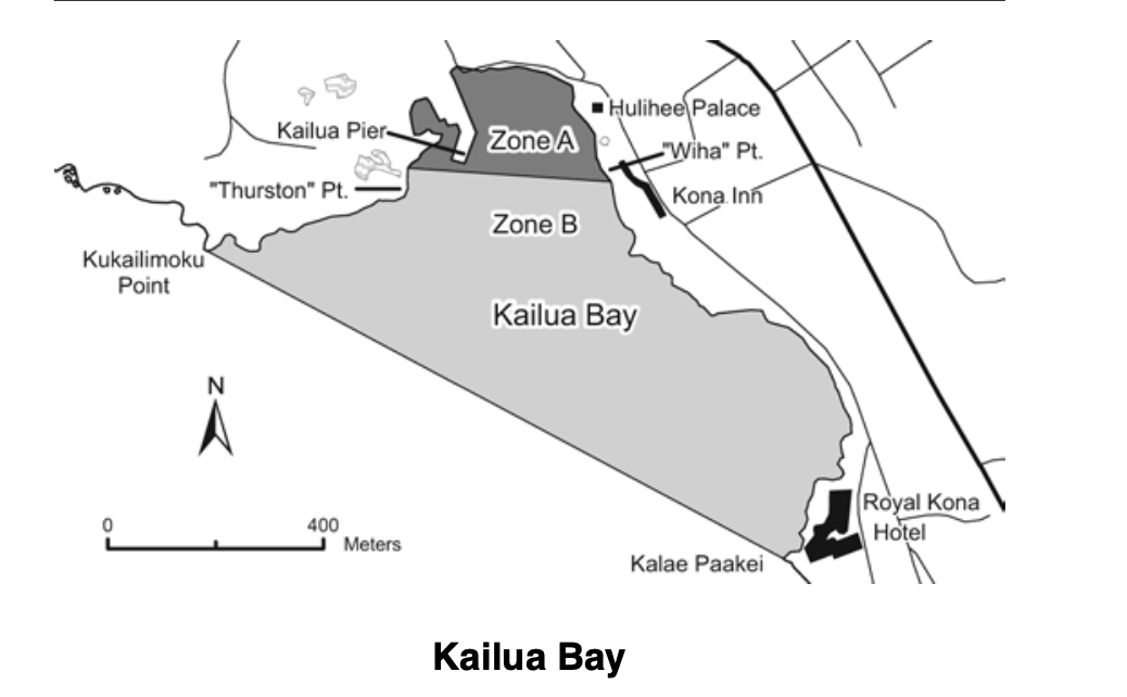
Location: That portion of Kailua Bay enclosed by a straight line drawn from Kukailimoku Point to the seawall of the Royal Kona Resort. A line from the northern edge of the channel at “Thurston Point” to the corner (“Wīha Point”) south of Hulihe’e Palace and north of the former Kona Inn Hotel separates Zone A (northwestern portion) from the seaward Zone B.
Permitted
- Take any legal-size fish in season with not more than two lines, or two rods and lines, and with not more than two hooks each.
- Take crabs with not more than 10 nets, provided nets are not more than two feet in diameter.
- Take shrimp for bait with a hand net, provided the net is not more than three feet in any dimension.
- Possess any spear or thrownet while transiting Zone A.
- Within Zone B only: use nets of mesh size not less than 3 inches to take fish, or akule net to take akule only; provided nets shall not be in the water between sunset and sunrise, or remain in the water except during active retrieval or unloading of fish from that net.
- Within Zone B only: use spears or thrownets.
- Commercial Marine licensees with a Bait License may take baitfishes.
- Licensed pond owners or operators may take young mullet (pua) or other small fish for stocking their fishpond.
Prohibited
- Snag or attempt to snag any fish.
- Herd, chase, or pa’ipa’i fish out of Zone A by swimming, diving, or from a boat, resulting in fish being taken by net.
- Otherwise fish for or take aquatic life, except as indicated in permitted activities above.
- Engage or attempt to engage in fish feeding.
Keauhou Bay Fisheries Management Area
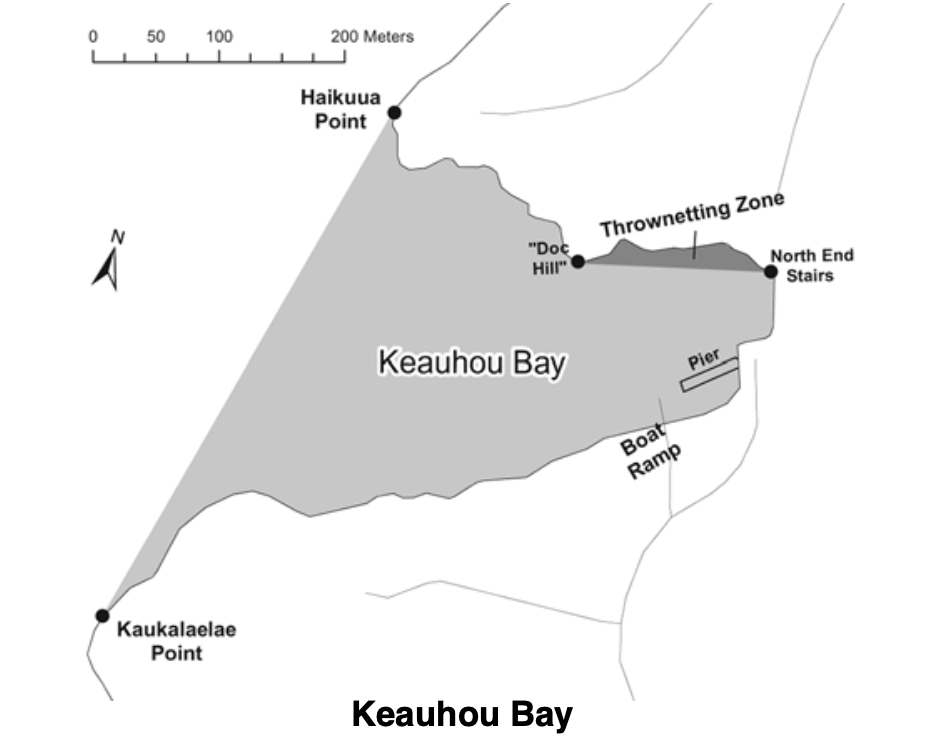
Location: That portion of the bay bounded by a straight line drawn from Haiku’ua Point to Kaukala’ela’e Point.
Permitted
- Take any legal-size fish in season with not more than two lines at the same time.
- Use hand nets not exceeding three feet in any dimension to take shrimp for bait purposes only, or to land fish already hooked.
- Use thrownets in the zone bounded by a straight line from “Doc Hill” to the north end stairs in the wall fronting the volleyball court.
Prohibited
- Snag or attempt to snag any fish.
- Use or possess nets, except as indicated in permitted activities above.
- Herd or chase any fish out of the area by swimming, diving, or using a boat.
- Engage or attempt to engage in fish feeding.
South Kona (Miloli’i)
Location: Waters off the coast of South Kona between the Ki’ilae-Kēōkea boundary and the Kapua-Kaulanamauna boundary.
Prohibited
- Fish for or take ‘ōpelu with fish or animal bait, except with hook and line.
Miloli’i Community-Based Subsistence Fishing Area (CBSFA)
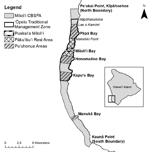
Location: Waters and submerged lands from the shoreline to the 100-fathom depth contour on the southwest coast of Hawai’i Island, from Pa’akai Point at Kīpāhoehoe in the north to Kaunā Point in the south. Contains numerous sub-zones. GPS coordinates can be found on the DAR website (administrative rules page, Part II, Chapter 60.10).
Sub-Zones and Shoreline Boundaries
| Sub-Zone | Boundaries |
|---|---|
| ‘Ōpelu Traditional Management Zone | From Nāpōhakuloloa (“2-Stone”) in the north to Kāki’o Point (Kaupō) in the south |
| Pu’uhonua Pāpā | From Lae o Kamimi in Pāpā Bay in the north to Makahiki Point in the south |
| Pāku’iku’i Rest Area | From Makahiki Point in the north to Kapulau (Honomalino Point) in the south |
| Puakai’a Miloli’i | From Kapukawa’aiki (Miloli’i Lighthouse) in the north to Lae Loa in the south |
| Pu’uhonua Honomalino | From Kapulau (Honomalino Point) in the north to Pūke’oke’o (Pōhaku Ke’oke’o) in the south |
| Pu’uhonua Kapu’a | From Kalapili (Okoe Bay) in the north to Kāki’o Point (Kaupō) in the south |
| Pu’uhonua Manukā | From Kamoi Point (north point of Manukā Bay) in the north to the south point of Manukā Bay |
Permitted
- Possess prohibited gear and restricted species while onboard a vessel in active transit, provided no prohibited gear is in the water.
- Fish outside the four Pu’uhonua except as indicated in prohibited activities below.
- Within the four Pu’uhonua:
- Fish from shore using throw net, scoop net, and hook-and-line
- Fish from a vessel using hook-and-line
- Fish using a pole spear
- Fish for akule using legal nets
Prohibited (Statewide)
- Aquarium fishing.
- Take or possess female ‘a’ama crab with eggs.
- Take or possess kole during March through June. From July through February: bag limit 20 per person per day, minimum size 5 inches.
- Take or possess ‘opihi kō’ele.
- Take or possess more ‘opihi makaiauli and ‘opihi ‘ālinalina (with shell) than can fit in a one-gallon size bag per person per day.
- Take or possess pāku’iku’i before July 1, 2027. Beginning July 1, 2027: bag limit 5 per person per day, minimum size 5 inches.
- Spear uhu at night using any gear type.
- Take or possess uhu ‘ele’ele or uhu uliuli.
- Take or possess uhu ‘ahu’ula or uhu pālukaluka during March through May. From June through February: minimum size 14 inches, maximum size 20 inches, bag limit 1 fish per person per day.
- Take or possess more than three other uhu per person per day; only one may be a terminal-phase uhu.
- Take or possess more than two ula per person per day.
- Take or possess any ‘ū’ū from April through June.
Prohibited Within Selected Areas
‘Ōpelu Traditional Management Zone:
- Take any ‘ōpelu except by hook-and-line from February through August.
The four Pu’uhonua:
- Harvest any ‘opihi.
- Fish using any gear or method other than indicated in “Permitted” above.
Pāku’iku’i Rest Area:
- Take or possess any pāku’iku’i.
Puakai’a Miloli’i:
- Use or possess any spear except pole spear.
- Spear any uhu, pāku’iku’i, weke ‘ula, moano kea, or ‘ū’ū.
- Use a lay net at night.
Scientific Names of Regulated Species
| Hawaiian Name | Scientific Name |
|---|---|
| ‘A’ama crab | Grapsus tenuicrustatus |
| ‘Opihi ‘ālinalina | Cellana sandwicensis |
| ‘Opihi kō’ele | C. talcosa |
| ‘Opihi makaiauli | C. exarata |
| ‘Ū’ū | genus Myripristis |