Kaua’i — Regulated Fishing Areas
Hanamā’ulu Bay and Ahukini Recreational Pier
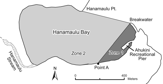
Location: The regulated region of the Hanamā’ulu Bay Fisheries Management Area is that portion of the bay, from the high-water mark seaward, bounded by a straight line from the tip of the breakwater westward to point “A.” The Ahukini Recreational Pier is a public fishing pier and a facility of the Division of State Parks (State Park rules also apply).
Prohibited
- Swim in Zone 1.
- Use any draw, drag, seine, or other type of net except thrownet, crab net, or landing net not more than 3 feet in any dimension (excluding handle) in Zone 1.
- Take or possess more than 75 akule or more than 5 mullet per person per day in Zone 1.
- Use any thrownet or spear within 50 yards of the Ahukini recreational pier, or from the adjoining pier frame.
- Snag any fish or possess any thrownet while on the Ahukini recreational pier.
Nāwiliwili Harbor and Port Allen
Location:
- Nāwiliwili Harbor — That portion of the harbor, from the high-water mark seaward, bounded by a straight line from the southernmost tip of the western pier northeast to the corner formed where pier 1 meets the eastern pier.
- Port Allen — That portion of Port Allen waters, from the high-water mark seaward, bounded by a straight line from the tip of the main breakwater northward to the bend in the breakwater of the small boat harbor.
Prohibited
- Use any net, except a landing net not more than 3 feet in any dimension (excluding handle).
- Snag any fish.
- Take or possess more than 75 akule per person per day.
Kapa’a and Waika’ea Canals
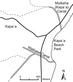
Location: Located in the city of Kapa’a on the east coast of Kaua’i.
Permitted
- Take any legal-size fish in season with one line, or one rod and line, with no more than two hooks.
- Take crabs with not more than 10 nets, provided the nets are not more than two feet in diameter.
- Take shrimp for bait with a hand net, provided the net is not more than three feet in any dimension.
- Commercial Marine licensees with a Bait License may take baitfishes.
- Licensed pond owners or operators may take young mullet (pua) or other small fish for stocking their fishpond.
Prohibited
- Fish for or take aquatic life, except as indicated in permitted activities above.
Waimea Bay and Waimea Recreational Pier
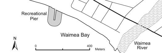
Location: Waimea Recreational Pier is a public fishing pier located in Waimea Bay on the southern coast of Kaua’i, and is a facility of the Division of State Parks (State Park rules also apply).
Prohibited
- Within 50 yards of the Waimea Recreational Pier: use any spear, trap, or any type of net except crab net.
- While on the Waimea Recreational Pier:
- Possess more than two fishing poles with one line each, or fish with more than two fishing lines, or leave any unattended fishing line in the water.
- Possess any thrownet.
- Reserve or occupy any space between the marks other than the one space personally occupied for fishing.
- Fish from any space between the marks already occupied by another fisherman.
Kōke’e Public Fishing Area
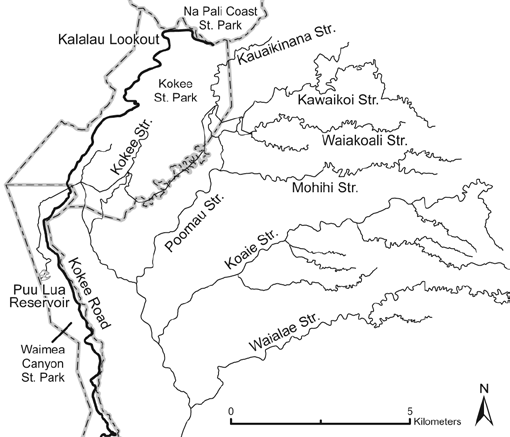
Location: Certain streams, reservoirs, and ditches in the Kōke’e State Park on Kaua’i.
Permitted
- During an open season announced by the Department on or about January 1 each year, and with a valid Freshwater Game Fishing License: fish for, possess, or remove rainbow trout with one pole and line, or one line using one baited hook attached to the single line.
- Fish only during the daily time period determined by the Department for that open season.
- Use a dip net up to two feet in longest axis (excluding handle) to land hooked trout.
- Take up to the maximum number of trout per licensee per day during the open season as determined by the Department for that season.
- All anglers must report before and after fishing activities at designated checking stations, and must allow inspection of any bag, container, vehicle, or conveyance used to carry or transport aquatic life.
Prohibited
- Fish for, take, or possess any rainbow trout except as described in permitted activities above.
- Use any form of corn for bait.
- Use treble hooks or more than one hook.
- Possess spears, chemicals, trotlines, or nets (except as indicated in permitted activities above) or other illegal fishing gear.
- Enter into or fish in the prohibited fishing zone along a portion of Kōke’e Stream and its tributaries above Camp Sloggett, or any other area posted as a prohibited fishing zone.
- Damage or mutilate any private or public property, or contaminate or pollute any stream, ditch, spring, water hole, or reservoir.
- Operate any vehicle in any fishing area except on roads for vehicular use, or use any aircraft to gain access for fishing purposes.
Wailua Reservoir Public Fishing Area
Location: Located off Kuamo’o Road approximately five miles mauka of Kūhi’ō Hwy, above the city of Wailua on Kaua’i.
Permitted
- With a valid Freshwater Game Fishing License: fish using one pole and line, or one line with one lure or baited hook attached to the single line.
- Use a dip net up to two feet in longest axis (excluding handle) to land hooked fish.
- Take up to an aggregate total of three fish per licensee per day; fishers must allow inspection of any bag or container, or any vehicle or other conveyance used to carry or transport aquatic life.
- Fish only during the day (no night fishing).
Prohibited
- Fish for, take, or possess any fish except as described in permitted activities above.
- Possess spears, chemicals, trotlines, or nets except as indicated in permitted activities above.
- Snag any fish.
- Possess or use any live animal or plant as bait.
- Enter into or fish from any irrigation infrastructure, including catwalks, valve towers, or ditches.
- Launch or use any vessel or floatable object (motorized, non-motorized, or wind-powered) on the reservoir.
- Swim, bathe, or conduct any activity in the reservoir other than fishing.
- Enter into or fish for any aquatic life at any portion of the reservoir designated as a wildlife or waterbird sanctuary.
- Contaminate or pollute the reservoir, ditch, or stream.
Bag and Size Limits (Wailua Reservoir)
| Species | Bag Limit | Size Limit | |———|———–|————| | Bluegill | 2 | 7 inches TL (minimum) | | Smallmouth bass | 2 | 9 inches TL (minimum) | | Largemouth bass | 2 | 9 inches TL (minimum), 14 inches TL (maximum) | | Tucunare | 2 | 12 inches TL (minimum), 15 inches TL (maximum) |
Note: Bag limits are listed for individual species. The aggregate total bag limit of three fish applies.
Hā’ena Community-Based Subsistence Fishing Area (CBSFA)
Location: Waters and submerged lands from the shoreline to a distance of one mile off the northwestern coast of Kaua’i, bounded by a straight line extending seaward at the boundary between Hā’ena State Park and Nā Pali State Park, and a straight line extending seaward at the boundary between Hā’ena and Wainiha.
Permitted
- Pole spears 8 feet or less.
- Up to two fishing poles per person, with no more than two hooks per line.
- Throw nets.
- Pa’ipa’i net or surround gill net fishing methods, as long as nets are deployed from shore or from a vessel less than 14 feet long; two people must be within five feet of the net at all times while deployed.
- Scoop nets (may not be used at night, between 6:00 pm and 6:00 am); limit of three specimens of marine life per day with scoop net.
- Taking of limu by hand harvest only.
- Vessels with prohibited gear onboard may transit through the CBSFA as long as they remain outside the Vessel Transit Boundary.
Prohibited
- Fish feeding.
- Taking of live shells.
- Taking of live or empty shells while using SCUBA.
- Spear guns.
- Spearing at night (between 6:00 pm and 6:00 am).
- Lay nets.
- Selling or offering for sale any marine life taken from within the area.
- Possession of prohibited fishing gear, except outside the Vessel Transit Boundary.
- Taking, altering, defacing, destroying, possessing, or removing any sand, coral, rock, or other geological feature or specimen.
Bag Limits
| Species | Limit | |———|——-| | ‘Opihi, pipipi, kūpe’e, and pūpū | 20 total combined per day (from the ‘Opihi Management Area only) | | Lobster | 2 per day; hand harvest only | | Urchins | 5 per species per day | | He’e | 2 per day; may be taken only by hand harvest or with a stick no more than two feet in length |
Regulated Areas Within the CBSFA
‘Opihi Management Area: Waters and submerged lands from the shoreline to a distance of 300 feet, from the Hā’ena/Nā Pali boundary of the CBSFA to a line extending seaward at the western edge of Ke’e Beach.
- Only place where ‘opihi, pipipi, kūpe’e, and pūpū may be harvested, beginning December 1, 2017.
Makua Pu’uhonua: Waters and submerged lands of Makua lagoon; a four-sided area bounded by:
- SW: 22°13’33.88” N, 159°33’42.41” W
- NW: 22°13’41.15” N, 159°33’44.67” W
- NE: 22°13’44.57” N, 159°33’34.71” W
- SE: 22°13’38.26” N, 159°33’31.56” W
No entry without a special activity permit (applies to vessels and individuals).
Vessel Transit Boundary: Waters and submerged lands bounded by a line drawn along the CBSFA boundary from the shoreline between Hā’ena State Park and Nā Pali State Park (Point “a”) at 22°12’42.50” N, 159°35’44.50” W to a point 1,000 feet offshore at 22°12’49.98” N, 159°35’51.79” W (VT1), eastward to a point 1,300 feet offshore at 22°13’35.57” N, 159°34’59.73” W (VT2), then to a point 2,300 feet offshore at 22°13’55.42” N, 159°33’42.00” W (VT3), then to a point 2,100 feet offshore at 22°13’48.84” N, 159°33’10.76” W (VT4), then along the CBSFA boundary to a point on the shoreline between Hā’ena and Wainiha (c) at 22°13’28.00” N, 159°33’13.50” W. This boundary does not affect general vessel operation or access to any area.
Scientific Names of Regulated Species
| Common Name | Scientific Name |
|---|---|
| Kūpe’e | Nerita polita |
| Lobster | family Palinuridae or Scyllaridae |
| ‘Opihi | genus Cellana |
| Pipipi | Theodoxus neglectus, Nerita picea, Neripteron neglectum |
| Pūpū | order Gastropoda or Bivalvia |
| Urchin | class Echinoidea |