O’ahu — Regulated Fishing Areas
Note: Hanauma Bay MLCD, Waikīkī MLCD, and Pūpūkea MLCD rules are listed below as they appear in the source regulations.
Hanauma Bay Marine Life Conservation District
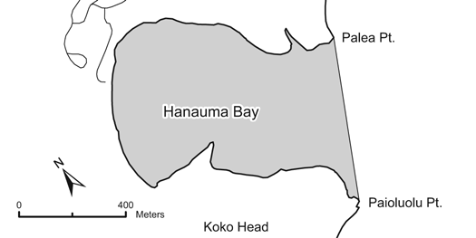
Location: Offshore of Hanauma Bay Beach Park, southeastern coast of O’ahu, from the high-water mark seaward to a line from Palea Point to Pai’olu’olu Point. Also designated as a State Underwater Park (Division of State Parks rules also apply).
Permitted:
- Possess a knife in the water for personal safety.
- With a permit, engage in activities otherwise prohibited for scientific, propagation, or other purposes.
Prohibited:
- Fish for, take, or injure any marine life (including eggs), or possess in the water any device that may be used for taking marine life.
- Take or alter any sand, coral, or other geological feature or specimen; or possess in the water any device used for taking or altering geological features.
- Introduce any food or other substance into the water to feed or attract marine life.
- Operate any watercraft.
Waikīkī Marine Life Conservation District
Location: From the groin at Kapahulu Avenue to the ewa wall of the Waikīkī War Memorial Natatorium, from the high-water mark out to a minimum seaward distance of 500 yards (or to the seaward edge of the fringing reef if it occurs beyond 500 yards).
Permitted:
- Possess in the water any knife, shark billy, bang stick, powerhead, or carbon dioxide injector.
- With a permit, engage in activities otherwise prohibited for scientific, propagation, or other purposes.
Prohibited:
- Fish for, take, or injure any marine life (including eggs), or possess in the water any device that may be used for taking marine life.
- Take or alter any sand, coral, or other geological feature or specimen; or possess in the water any device used for taking or altering geological features.
Pūpūkea Marine Life Conservation District
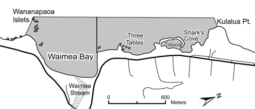
Location: Northern coast of O’ahu, from the high-water mark seaward, bounded by a line extending due west from Kulalua Point to a point 100 yards offshore, then south to the most seaward exposed rock of Wananapaoa Islets on the south side of Waimea Bay (including the islets), then due southeast to shore.
Permitted:
- Take and possess up to two pounds (combined total, squeezed dry) of limu kohu and limu lipe’epe’e by hand harvest only (holdfast must be left in place).
- Possess a knife for personal safety.
- Within Waimea Bay only: Take and possess any finfish with hook-and-line from shore (no more than two poles per person, one line per pole, no more than two hooks per line).
- Within Waimea Bay only (seasonal): Take with legal nets and possess ‘opelu during August and September, and akule during November and December.
Prohibited:
- Fish for, take, injure, kill, possess, or remove any marine life (including eggs), except as indicated in permitted activities above.
- Take or alter any geological feature or specimen.
- Possess in the water any device that may be used to take marine life, or alter any geological feature.
- Introduce any food or other substance into the water to attract marine life (except as permitted for fishing in Waimea Bay).
- Snag any akule while fishing from the shore of Waimea Bay.
Warning: Hazardous to enter water during periods of high surf along the North Shore.
Waikīkī-Diamond Head Shoreline Fisheries Management Area
Location: From the ‘Ewa wall of the Waikīkī War Memorial Natatorium to the Diamond Head Lighthouse, from the high-water mark out to a minimum seaward distance of 500 yards (or to the seaward edge of the fringing reef if one occurs beyond 500 yards).
Fishing Periods
- “Open to fishing” — January 1 to December 31 of even-numbered years
- “Closed to fishing” — January 1 to December 31 of odd-numbered years
Permitted
- During “open to fishing” period: fish for, take, or possess any legal-size marine life in season, provided only hook-and-line, thrownet, handnet (to land hooked fish), spear fishing, and hand harvesting methods are used.
- With a permit, engage in activities otherwise prohibited for scientific, propagation, or other purposes.
Prohibited
- During “closed to fishing” period: fish for, take, or injure any marine life (including eggs), or possess any fishing gear in the water.
- During “open to fishing” period: use any spear between 6:00 pm and 6:00 am; have or possess in the water any trap or net except thrownet or handnet to land hooked fish.
- From one-half hour after sunset to one-half hour before sunrise:
- Use or possess any spear while diving
- Possess both diving equipment and a spear at the same time
- Possess both diving equipment and any specimen of speared aquatic life at the same time
Transit Through the FMA
Prohibited gear and restricted species may be possessed while onboard a vessel in active transit, provided no prohibited gear is in the water. Vessels adrift, anchored, or moored are not considered to be in active transit (except for vessels in line for the boat ramp and vessels actively loading/unloading at the wharf or shore).
Scientific Names of Regulated Species
| Common Name | Scientific Name | |————-|—————-| | ‘Alakuma | Carpilius maculatus | | Horned helmet | Cassis cornuta | | Triton’s trumpet | Charonia tritonis |
Honolulu Harbor
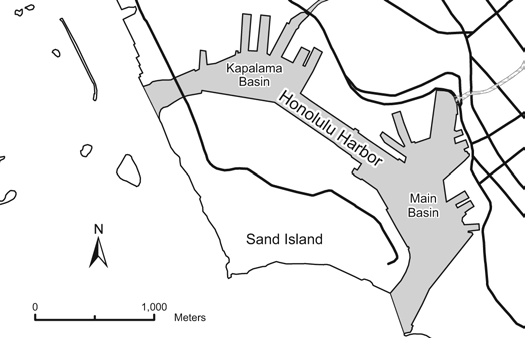
Location: Primary port on the southern coast of O’ahu.
Permitted
- Commercial Marine licensees with a Bait License may take baitfish during periods scheduled by the harbor master.
Prohibited
- Unlawful to take fish by means of any draw, drag, or seine net.
Note: All boaters must be in contact with the harbor controller (VHF Ch. 12) whenever operating in Honolulu Harbor.
Maunalua Bay Fisheries Management Area
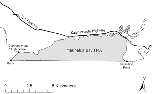
Location: Southeastern coast of O’ahu, from the high-water mark seaward to a straight line extending from the southern tip of Kawaihoa Point (Spitting Caves) westward to the Diamond Head buoy, then a straight line from the buoy to the Diamond Head lighthouse.
Prohibited
- Take or possess any specimen of the following species: ‘alakuma (seven-eleven crab), horned helmet, Triton’s trumpet, ula (spiny lobster), or ula pāpapa (slipper lobster).
Coconut Island — Hawaii Marine Laboratory Refuge
Location: Reefs and bay waters surrounding Coconut (Moku-o-Loe) Island in Kāne’ohe Bay, from the high-water mark on the island seaward to twenty-five feet beyond the outer edges of the reefs.
Prohibited
- Unlawful to take any aquatic life from within the boundaries of the refuge.
Exceptions
- Does not apply to any officer, faculty member, employee, or student of the University of Hawai’i, or licensee of the Board of Regents, while catching or taking aquatic life for scientific purposes. All authorized taking must follow minimum size and closed season requirements, gear restrictions, etc.
Ala Wai Canal & Kapālama Canal
Location:
- Ala Wai Canal — Immediately north of Waikīkī; includes the Manoa-Pālolo drainage canal at the mouth of Manoa and Pālolo Streams.
- Kapālama Canal — At the mouth of Kapālama Stream, north of Sand Island.
Permitted
- Take any legal-size fish in season with one line, or one rod and line, with no more than two hooks.
- Take crabs with not more than 10 nets, provided the nets are not more than two feet in diameter.
- Take shrimp for bait with a hand net, provided the net is not more than three feet in any dimension.
- Within the Ala Wai Canal only: take up to 50 “tabai” or mosquito fish, ‘o’opu akupa, tilapia, or a combination thereof per day for non-commercial purposes, with a single small mesh net, provided the net including handle and any attachment is not more than three feet in any dimension.
- Commercial Marine licensees with a Bait License may take baitfishes.
- Licensed pond owners or operators may take young mullet (pua) or other small fish for stocking their fishpond.
Prohibited
- To fish in or take aquatic life, except as indicated in permitted activities above.
He’eia Kea Wharf
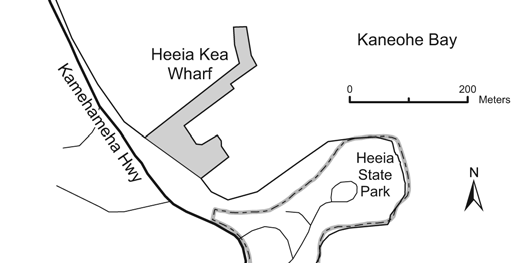
Location: He’eia Kea Boat Harbor on Kāne’ohe Bay, O’ahu.
Permitted
- Take any legal-size fish in season with one line, or one rod and line, with no more than two hooks.
- Take crabs with not more than 10 nets, provided the nets are not more than two feet in diameter.
- Take shrimp for bait with a hand net, provided the net is not more than three feet in any dimension.
- Commercial Marine licensees with a Bait License may take baitfishes.
- Licensed pond owners or operators may take young mullet (pua) or other small fish for stocking their fishpond.
Prohibited
- To fish in or take aquatic life, except as indicated in permitted activities above.
Pōka’ī Bay
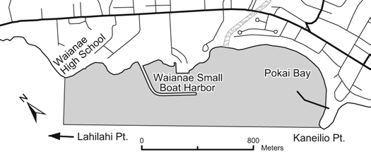
Location: That portion of Pōka’ī Bay including the Pōka’ī Boat Harbor and the Wai’anae Small Boat Harbor, the seaward boundary a straight line from Kane’ilio Point to Lahilahi Point, and the northwestern boundary a straight line extending southwest from the point immediately seaward of Wai’anae High School.
Permitted
- Take any legal-size fish in season with one line, or one rod and line, with no more than two hooks.
- Take crabs with not more than 10 nets, provided the nets are not more than two feet in diameter.
- Take shrimp for bait with a hand net, provided the net is not more than three feet in any dimension.
- Commercial Marine licensees with a Bait License may take baitfishes.
- Licensed pond owners or operators may take young mullet (pua) or other small fish for stocking their fishpond.
Prohibited
- To fish in or take aquatic life, except as indicated in permitted activities above.
Waialua Bay (Hale’iwa Harbor)
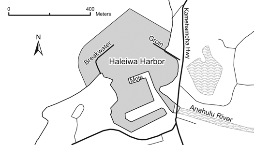
Location: That portion of Waialua Bay at Hale’iwa bounded by lines drawn 100 yards seaward of and parallel to the Hale’iwa Harbor Breakwater and 100 yards seaward of and parallel to the Hale’iwa Beach Groin, and inland by a line ten yards downstream of and parallel to the Anahulu Bridge.
Permitted
- Take any legal-size fish in season with one line, or one rod and line, with no more than two hooks.
- Take crabs with not more than 10 nets, provided the nets are not more than two feet in diameter.
- Take shrimp for bait with a hand net, provided the net is not more than three feet in any dimension.
- Commercial Marine licensees with a Bait License may take baitfishes.
- Licensed pond owners or operators may take young mullet (pua) or other small fish for stocking their fishpond.
Prohibited
- To fish in or take aquatic life, except as indicated in permitted activities above.
Wahiawā Public Fishing Area
Location: A portion of the privately-owned Wahiawā Reservoir (Lake Wilson) in central O’ahu. The Wahiawā State Freshwater Park (located along the South Fork) includes a boat launching ramp and vehicle-trailer parking. Rules of the State Parks System also apply.
Permitted
- Fish with hook-and-line with not more than one lure or baited hook or two artificial flies attached to a single line.
- Weekends and holidays: one line only
- Weekdays (other than holidays): two lines permitted
- Use attended traps and dip nets up to two feet long, wide, or high (excluding the handle) to land hooked fish or take certain baitfishes, provided that tucunare, bass, channel catfish, and oscar shall not be used as bait.
Prohibited
- To enter or fish without a valid Freshwater Game Fishing License and entry permit (or other appropriate license/permit), a USCG-approved personal flotation device; all licensees/permittees under 15 must be accompanied by an adult.
- To enter onto, fish from, or approach within 200 feet of the spillway dam and its shoreline, or to enter into or fish within the Forest Reserve along the North Fork.
- To swim, water ski, camp, picnic, build fires, dispose of refuse, or pollute the waters; or damage public or private property.
- To possess any firearms, air rifles or pistols, bows and arrows, spear, trotlines, nets other than dip nets, chemicals, or other illegal fishing gear.
- To snag any fish.
- To operate a boat exceeding 18 feet in length, or for purposes other than fishing, or at speeds in excess of five miles per hour, or constructed of material other than wood unless provided with flotation to render the boat unsinkable.
Exceptions to Size and Bag Limits
- Bass and tucunare: Catch and release fishing only. Unlawful to keep, retain, hold, or kill any bass or tucunare. Any bass or tucunare brought to shore or on board a vessel must be returned to the water immediately.
- Oscar: Bag limit 1.
Nu’uanu Freshwater Fish Refuge
Location: City and County of Honolulu’s Nu’uanu Reservoirs No. 2, 3, and 4, located between Honolulu and Kailua off the Pali Highway on O’ahu.
Prohibited
- To enter into the refuge unless accompanied by an agent of, or with a permit issued by, the Board of Land and Natural Resources.
Note: Nu’uanu Reservoir No. 4 is now closed to fishing.
‘Ewa Limu Management Area
Location: Waters off ‘Ewa Beach on the south shore of O’ahu, from the western edge of the gunnery range to Mu’umu’u Place, from the shoreline 150 feet seaward.
Permitted
- Hand-pick up to one pound of all types of limu combined per person per day, from 6:00 am to 6:00 pm, during the months of July, November, and December.
- Exercise native Hawaiian gathering rights and traditional cultural practices as authorized by law.
Prohibited
- Pick, gather, harvest, or otherwise take limu except as described above without a permit.